 View Our Strategy Document 2019 – 2024

August 30, 2024


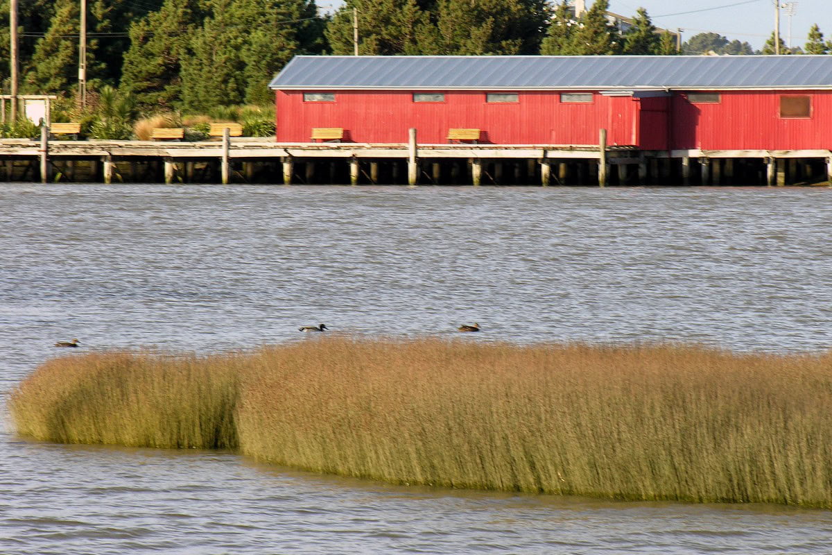
Land Use Suitability
Land use suitability tools and assessment processes for increasing land use diversity and delivering better community outcomes.
Project Details Ngā taipitopito
Project Status:
Challenge funding:
$2,750,000Research duration:
June 2016 – December 2019Collaborators Ngā haumi
AgResearch | Environment Canterbury | Environment Southland | GNS Science | Manaaki Whenua Landcare Research | NIWA | Plant & Food Research | Streamlined Environmental | Te Tumu Paeroa | Tipa and Associates | University Of Otago
What are we doing?E aha ana mātou?
Land use planning in New Zealand currently focuses on what a parcel of land is capable of producing, with the increasing use of regulatory limits. These limits will be more easily met when land use planning considers the conditions of water bodies downstream, and the economic, environmental, social and cultural values of the surrounding community.
We call this broader planning perspective ‘land use suitability’.
To enable this shift in perspective, we need more detailed understanding of the land’s natural attenuation processes, which reduce levels of contaminants like nitrogen and phosphorus, and the resilience of water bodies.
Land Use Suitability research is linking these natural processes with human interventions, mitigations and land-management choices, to make the consequences of our choices clearer and more predictable.
How can the research be used? Ka pēhea e whai take ai te rangahau?
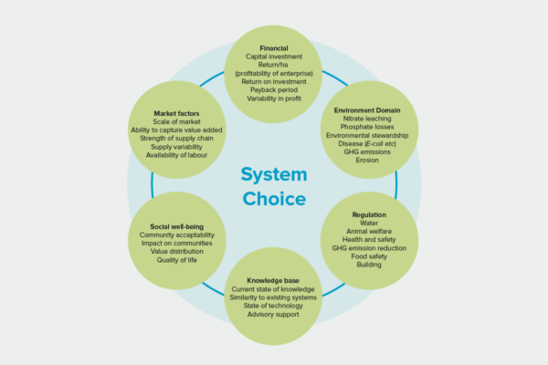
- This research developed the land-use suitability (LUS) framework, focused on conveying information about the productive potential of land and the susceptibility of water bodies connected to land parcels. This will support the development of tools for land owners and investors to evaluate a range of land uses suitable for individual land parcels, and for central and local government to estimate land-use effects such as contaminant loss.
- This research has divided the country into typologies, used simulation modelling for 5 land uses on each typology, and used a combination of empirical modelling and direct transfer to extend from the typologies to coverage of all land parcels in the country. The approach has proven sound, but requires additional data to represent all land uses nationally.
- A second phase of research will expand the scope to consider a broader range of constraints and pressures, including greenhouse gas emissions. It will add up to a dozen additional land uses, extended to all land parcels.
- Researchers and collaborators have trialed the LUS assessment processes in real-world decision-making. Hawkes Bay Regional Council partnered with the LUS team to apply their research to decision-making processes. Environment Southland took a critical role in co-developing the LUS concept and providing reality checks and guidance about real-world applications. It tested application of Land Use Suitability (LUS) in the Oreti catchment in 2018.
- The research team brought together every scrap of available spatial data in the country, in every possible model, to produce maps for every farmable parcel in Southland. A prototype land use planning support tool, the Land Use Suitability Analyser, was developed and tested using the Southland data, bringing together multiple existing tools (digital river network, Sparrow catchment model, Overseer nitrogen model, Land Use Capability classification, and spatial data layers with physiographic zones). This tool focused on nitrogen as the land use pressure of concern, and the impact of changing land use on water quality and farm profit. A national-scale pressure layer, incorporating lakes, was developed.
- The LUS concept was discussed by the Land and Water Forum in advice to the Minister for the Environment about the allocation of nutrient discharge allowances on-farm and in a catchment. Scott Larned met with the Parliamentary Commissioner for the Environment staff to discuss applications of the LUS concept.
- 7 industry stakeholders (DairyNZ, RaboBank, Fonterra, Beef + Lamb NZ, the Foundation for Arable Research, LandCorp, IrrigationNZ) are all actively collaborating with researchers to develop land use suitability tools into industry policy or advice.
Related research updates Ngā pānui mō te rangahau nei


Participation & engagement Te hunga i whai wāhi mai
- Land Use Suitability has liaised with 6 regional councils (Environment Southland, Envionment Canterbury, Greater Wellington Regional Council, Waikato Regional Council, Environment Bay of Plenty, Horizons) on their current planning processes and the potential for application of the Land Use Suitability concept.
- In collaboration with several runanga, cultural assessments were conducted at 170 sites in Otago and Canterbury, assessing land use impacts on Māori cultural values. The results of this work and its potential applications were discussed with three runanga in a hui series.
- Land Use Suitability researchers participated in the Innovation Market hosted by the Collaboration Lab. Amy Whitehead explained and demonstrated the Land Use Suitability Analyser, and Scott Larned facilitated a discussion of land use, environmental effects and kaitiakitanga in the Te Waihora catchment. The target audience included researchers, entrepreneurs and the Next Generation Influencers.
Research team Te hunga i whai wāhi mai
Research Lead
Scott Larned
NIWA
Linda Lillburne
Manaaki Whenua Landcare Research
Ton Snelder
Land Water People
Simon Harris
Land Water People
Marc Schallenberg
University of Otago
Amy Whitehead
NIWA
Doug Booker
NIWA
Mike Beare
Plant & Food Research
Richard McDowell
AgResearch
Gail Tipa
Ngai Tahu
Tipa & Associates
Shannan Crow
Te Atiawa
NIWA
Tony van der Weerden
AgResearch
Anne-Gaelle Ausseil
Manaaki Whenua Landcare Research
Edmar Teixeira
Plant & Food Research
Tools & resources Ngā utauta me ngā rauemi
Summary
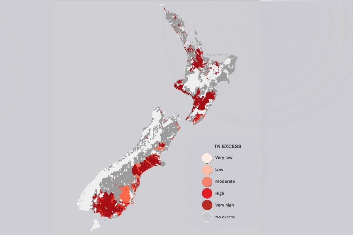
Online Tools Show Where Land-Use Change Needs to be Considered
We now know where land use needs to change, to meet New Zealand policy expectations for water quality. This article was prepared as an impact…
Guidance
Management Practices to Improve Water Quality (learning module)
This kōwae (learning module) will help you support farmers in creating cost-effective freshwater environment plans using science from Our Land and Water. You will learn:…
Guidance
Tools for Making Land Use Change Decisions (learning module)
Work through the activities in this kōwae (course) to learn how to help farm businesses to make decisions about land use diversification. You will learn:…
Interactive Tool
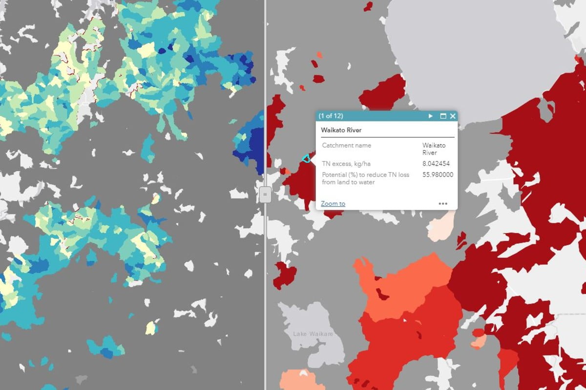
Map of Total Sediment Yield and Reduction Potential
An interactive map shows the total sediment yield and the potential for mitigation strategies to reduce sediment losses from land to water by 2035. The…
Interactive Tool
Map of Total Phosphorus Yield and Reduction Potential
An interactive map shows the total phosphorus (TP) yield and the potential for mitigation strategies to reduce TP losses from land to water by 2035.…
Interactive Tool
Actions to Include in a Farm Environment Plan
This interactive infographic is a compilation of actions to decrease the loss of contaminants from agricultural land. Mitigation actions can be filtered by any of…
Academic outputs He whakaputanga ngaio
Journal Article
Phenotyping early-vigour in oat cover crops to assess plant-trait effects across environments
Early-vigour is a plant trait phenotypically characterised by a rapid expansion of leaf area in early stages of crop growth, before canopy closure. Although early-vigour…
Journal Article
Continuous measures of confidence in direction of environmental trends at site and other spatial scales
Managers and decision-makers need to know if variables measured by environmental monitoring programs are increasing or decreasing, both at individual sites and at larger spatial…
Journal Article
Developing an indicator of productive potential to assess land use suitability in NZ
The Land Use Suitability (LUS) concept is composed of three indicators describing the inherent productive and economic potential of land parcels (productive potential), the contribution…
Journal Article
On the use of stressor-response relationships in the management of lake eutrophication
Since the 1960s, theoretical and empirical advances in limnology have offered lake managers different approaches to address lake eutrophication problems. The Vollenweider input–output model and…
Journal Article
Incorporating Māori values into land management decision tools
Environmental sustainability and the long-term wellbeing of Māori (the indigenous people of New Zealand) are interdependent and degradation of landscapes risks the progressive degradation of…
Journal Article
Nitrogen loads to New Zealand aquatic receiving environments: Comparison with regulatory criteria
There is concern about the deteriorating nutrient status of aquatic receiving environments in New Zealand. We estimated the amount by which current nitrogen (N) concentrations…
In the media Mai i te ao pāpaho
Farmers Weekly, 7 December 2021
[Dr Donovan] says the national maps are not likely to be immediately useful to regional councils, catchment groups, or individual farmers who want to understand their farm, but in those cases, he recommends getting in touch to explore the appropriate options to develop a regional, catchment or individual farm map that accounts for specific grazing densities at paddock scales.
Farmers Weekly, 28 February 2020
Nitrate leaching will be higher and more variable with more extreme rain leading to more frequent nitrate leaching. The most noticeable increase modelled was in a Southland case study where annual leaching increases significantly with more spring rain and more frequent extreme rain but more research is needed to confirm the trend.
Dairy News, 4 March 2020
The report also identified for dairy, sheep and beef that heat stress will be an increased risk for animal health, with about two additional weeks of risk for moderate heat stress by the 2090s, and a more pronounced risk of severe heat stress. Provision of more shade and shelter will be needed.
NZ Herald, 26 February 2020
"We hope this research will further encourage long-term strategic adaptation, such as diversifying cultivars, shifting sowing dates and planning additional shade and shelter" said Anne-Gaelle Ausseil of Manaaki Whenua Landcare Research, principle investigator in the research.
Stuff, 27 February 2020
Depending on the farm or vineyard, adapting to climate change might mean planting different grape varieties, sowing maize for cow-feed earlier, changing fertiliser patterns, or protecting cows from over-exertion on hot days, the research says. The key is to start planning early.
Stuff, 17 October 2019
Extreme events may impact on loss of nutrients into rivers, animal heat stress in summer, or late frosts during flowering grapes. How do we make decisions about land use that can accommodate all this?
NZ Geographic, Mar-Apr 2018
“Cynical people would recognise that we’re trying to figure out to what degree we might have our cake and eat it, too. Of course, the truth is, you can’t” – Scott Larned
NZ Geographic, July-August 2017
Scott Larned, a NIWA ecologist with a strong interest in how ecosystems interact with water, told me it can take 60 to 100 years for rainwater falling on the upper Canterbury Plains to percolate to the ocean
Related news
Future Landscapes Projects
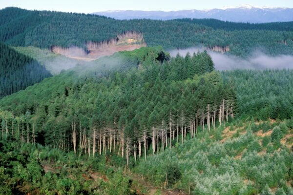
Visualising Forestry Harvesting Cycles
Future risk planning through the visualisation of forestry harvesting cycles. For full information see the programme website
This project has produced
Matarau: Empowering Māori Landowners in Land Use Decisions
Providing accessible and useful data to support Māori landowners to prioritise land-use options. For full information see the programme website
This project has produced
Next Generation Systems
Identifying next generation primary production systems and opportunities to change the face of farming
This project has produced
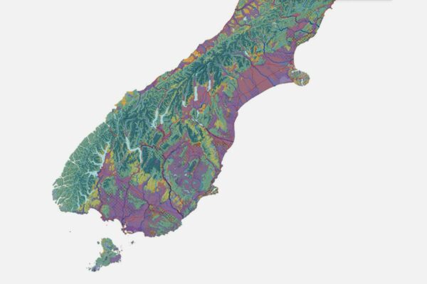
Physiographic Environments of New Zealand
Integrating landscape process knowledge with water chemistry to understand how and why surface water quality varies across New Zealand
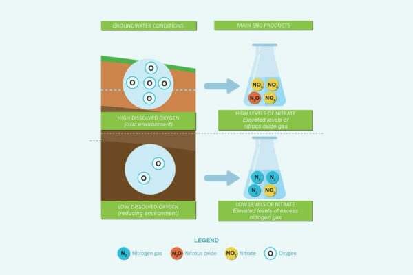
Benign Denitrification in Groundwaters
Developing a cost-effective technique to assess denitrification processes and end products in shallow groundwaters
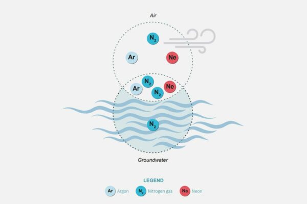
Measuring Denitrification
The development of a method for measuring denitrification is a first for New Zealand, providing vital data for understanding natural denitrification processes
This project has produced