View Our Strategy Document 2019 – 2024

August 30, 2024


Our Land and Water has now ended.
Our mission was to preserve the most fundamental treasures of Aotearoa – its land and water – while producing value from those same treasures.

Resource Finder
Use one, some or all the filters below to explore our resources, tools & research.
Know what you are looking for? Type below
Or, use our filtered search by selecting as little or as much as you like.
Infographic
Future Land Use Opportunities illustration
An illustration of a diversified farm of the future in Aotearoa New Zealand. Right-click to open image in a new tab to download at the…
Journal Article
Physiographic Environment Classification: a Controlling Factor Classification of Landscape Susceptibility to Waterborne Contaminant Loss
Spatial variation in the landscape factors climate, geomorphology, and lithology cause significant differences in water quality issues even when land use pressures are similar. The…
Summary
Biodiversity Credits to Fund Land-Use Change on the Table
There is no universal solution to financing land-use change in Aotearoa, according to new research, but new devices like biodiversity credits show promise, as do…
Video
Worker Requirements Webinar
Labour shortages in the agrifood sector were highlighted when Covid-19 closed borders, but the underlying shortages go back further. For example, the conversion of sheep,…
Technical Report
Creating a diverse and sustainable dairy farming and forestry landscape
Analysis of the results and discussion indicates that our hypothesis did not eventuate. There was not the increase in pasture production in the ‘shade' environment…
Mauri Whenua Ora
Unlocking the potential of Māori land by advancing new production systems and market opportunities, using a mātauranga-centred framework
Journal Article
Enabling a transformation to a bioeconomy in New Zealand
The 2009 OECD call for a global transition towards a bioeconomy has resulted in a number of nations adopting national or regional strategies to develop…
Video
Winning the Green Premium: Beverage Sector webinar
Beverage consumers are demanding ever-greater sustainability in their drinks. That comes with a financial cost. How can producers earn more to cover these new costs?…
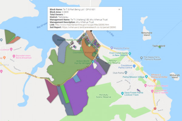
Where are we conducting our research?
This interactive map shows the location of all our research projects to help connect you with the research happening in your catchment.
Hover over regions and click to see key information about the projects.
Our Key Collaborators