 View Our Strategy Document 2019 – 2024

August 30, 2024


Orbiting Kiwifruit Water Meters
Satellites passing overhead could assess water in kiwifruit canopy leaves and help identify when irrigation is needed. As councils tighten up on water allocations, keeping track of water use in kiwifruit and other orchards is important and will become even more so as climate variability increases.
The kiwifruit industry is under the hammer. A serious shortage of labour due to Covid-19 is behind a drop off in the quality of export fruit. Our reputation in our overseas markets has taken a serious hit.
Repairing this damage will mean taking extra care with production and handling over the coming years. Getting irrigation right, especially in the crucial lead-in time to harvest through the heat of summer, has a direct impact on the quality of the fruit.
“Unless you test the plant you don’t know if you’re over-irrigating or under-irrigating,” says Ash Neilson of RICARDO based in the Bay of Plenty. “For some orchardists it comes down to guesswork or gut feeling.”
Compounding this, orchards can have variations in soil type that affect how much water is retained or lost in the soil.
The value of getting irrigation right isn’t just reserved to upping fruit quality. Many of the orchards that RICADO manage take water from streams. Ash notes that regional councils are tightening up more each year on resource consents and allocations for water out of streams and bores.
“Some areas have also been over-allocated for water in the past, and councils are being much tougher with new resource consents and monitoring existing consents,” says Ash. If the flow gets too low, water take can be restricted or stopped.
“There are a growing number of orchardists who are technology-minded and forward-thinking. They’re already doing remote soil moisture testing,” Ash says. “More and more managers are managing larger orchards and don’t have the time to micro-manage. Their long-term goal is to get to the point where irrigation is automatic.”
To do this, more accurate data is needed than is currently available.
Funding from the Rural Professionals Fund from the Our Land and Water National Science Challenge was granted to find out if Synthetic Aperture Radar (SAR) satellite technology, which uses microwave technology and isn’t weather or daylight-dependent, could accurately gauge the water content of foliage in kiwifruit canopies and nail down when plants are stressed. The digital data could also be used on data platforms.
Getting underway
Trialling was held on Ngāi Tukairangi Trust’s orchard blocks on Matapihi Peninsula in Tauranga from November 2021 to March 2022. The orchards are on highly productive, well-drained loam
soils with flat-to-undulating terrain, and with six blocks in an orchard chosen. Two blocks were growing the Hayward green variety and four blocks the gold cultivar.
Soil moisture data was provided from remote soil moisture sensors. Teros 10 soil moisture sensors were installed in the centre of each block at 300 and 600 mm depths in October 2021, with raw data calibrated in accordance with the manufacturer’s guidelines. Fifteen-minute readings gave near real-time data and were sent to RICADO’s online network.
This data was then correlated with rainfall events from a local weather station just 3.2 km away at Tauranga Airport. Daily rainfall and soil water deficit datasets came from here using NIWA’s national CliFlo open- access online climate database.
On days that the satellite was to pass overhead, leaves from the canopy were collected from the same bay in each block, sealed and sent for water content testing by technicians from Eurofins Laboratory.
Eye in the sky
Data from the orbit was to come from two SAR Sentinel-1 satellites operated by the European Space Agency’s Copernicus programme. Operating since 2016, Copernicus allows a full and open licence to all Sentinel data for research. Following each other around sees one of the satellites cross over the orchard every four to six days.
But the research had only been underway for a month when one of the satellites malfunctioned. This saw data coming from the remaining satellite once every 12 days. The data collected by the remaining satellite was considered enough to prove the concept, and the trial continued.
An alternative was then also sought, with Earth Observation company ICEYE’s SAR satellites, which uses different radio wave lengths, providing separate data from mid-February. Results suggested it too would be accurate enough for its own modelling.
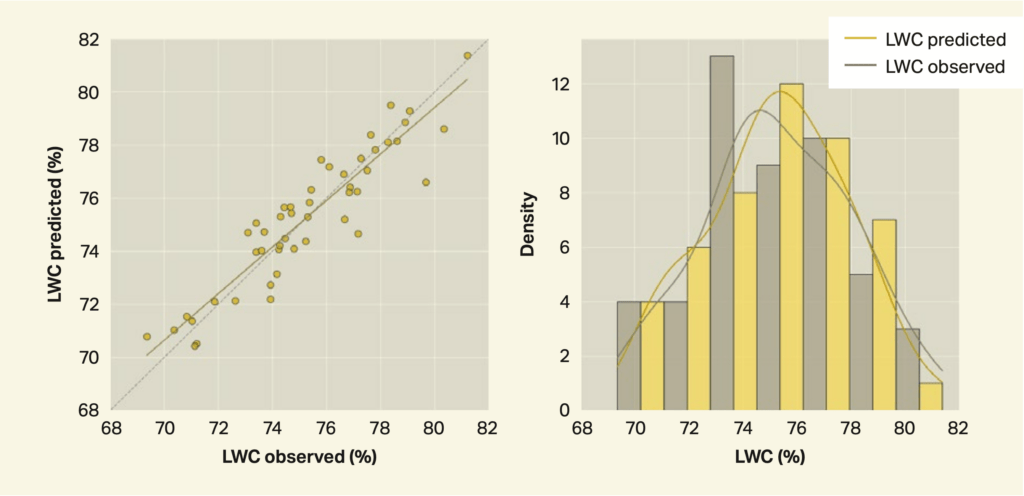
In the end, only the Sentinel data was used. This showed a close agreement with ground-based lab results for the water content in the leaves, which suggested the amount of water present in canopy leaves could be accurately predicted over time (Figure 1).
Some additional work might be needed around hail netting, because the satellite constantly over- estimated leaf water content on the single block that netting was used on.
Sensors and satellite agree
The soil sensors showed soil moisture increases after rainfall and irrigation, particularly at 300 mm, and falling moisture in the soil between these events. There was more and more constant moisture at 600 mm. Comparing soil moisture and leaf water content measured on the same day confirmed there was a relationship between them.
Significantly, it also showed the Hayward green variety stores less water in its leaves than the gold cultivar.
This difference was also picked up in the satellite data. Microwaves from the satellite were stronger as the leaves took in more water, as well as more microwaves bouncing back (backscatter) as the leaves got fuller. Backscatter from Hayward green foliage was generally lower than for the gold. This would need to be taken into consideration when both assessing data and with predictive modelling using SAR.
From there, modelling was used to create 3D maps of leaf water content on 100 blocks in the orchard.
ArcGIS Online is web-based software that allows interactive maps to be created and shared. Different layers of information can be incorporated into the maps. This type of layering is very good at separating out and visualising ‘like’ information from within large data sets.
The maps and data were uploaded into a dashboard created by the software. This meant different aspects of the data could be visualised, so trends could be seen between the different blocks and vine varieties in the orchard. This included thresholds for when blocks might be water stressed.
The group was pleased with the dashboard. This type of presentation of leaf water content data they felt would be a useful platform for growers to identify water stressed areas, as well as tracking changes in leaf water content. This would help optimise water use within different parts of the orchard with different soil types.
Incorporating other relevant orchard information included doing so on web-based grower networks like RICADO’s, so that other real-time information could be visualised in this way, and this was also seen as a further improvement.
Using satellite technology to monitor kiwifruit canopy water content
Why: To see if satellite monitoring of kiwifruit orchard canopies using microwave sensors called Synthetic Aperture Radar (SAR) satellites could more accurately show when irrigation is needed, given the variable soils within an individual orchard, and lead to better water management.
Where: Kiwifruit orchard on Matapihi Peninsula in Tauranga.
Who: Ash Neilson (RICADO Group), Colin Jenkins and Andrew Wood (Ngāi Tukairangi Trust), Phillip Green and John Huntingdon (RICADO Group), Dr Istvan Hajdu and Professor Ian Yule (PlantTech).
What:
- Data from SAR satellites is accurate enough to map the water content in kiwifruit canopies and can distinguish between varieties.
- Water content in leaves correlates with soil moisture from irrigation and weather events.
- The Hayward green variety of kiwifruit was found to store less water in its leaves than the gold cultivar.
- SAR satellites can provide data in any weather and at night, so passes should be more frequent (as close to daily as possible) to give the most accurate information.
- Modelling should be implemented soon to detect both water stress in vines and to avoid over-irrigation.
- Incorporating modelling into dashboards visualises orchard data, making it easier for orchardists to make better decisions around increasing yield, preserving freshwater resources and reducing fruit variability.
Read more: Using satellite technology to monitor kiwifruit canopy water content: Final report
Author
Leave a Reply