View Our Strategy Document 2019 – 2024

August 30, 2024


Our Land and Water has now ended.
Our mission was to preserve the most fundamental treasures of Aotearoa – its land and water – while producing value from those same treasures.

News
Resource Finder
Use one, some or all the filters below to explore our resources, tools & research.
Know what you are looking for? Type below
Or, use our filtered search by selecting as little or as much as you like.
Presentation
Journal Article
National-scale implementation of mandatory freshwater farm plans: A mechanism to deliver water quality improvement in productive catchments in NZ?
Reducing agriculturally derived diffuse contaminant losses (via non-point sources) from land to water has proven difficult for decades. Owing to the diversity and complexity of…
Journal Article
On the use of stressor-response relationships in the management of lake eutrophication
Since the 1960s, theoretical and empirical advances in limnology have offered lake managers different approaches to address lake eutrophication problems. The Vollenweider input–output model and…
Technical Report
Establishing perennial ground cover species, as a management practice to suppress weeds in a pipfruit orchard’s “weed spray strip”
Can low-growing, perennial plants be established as a ground cover in pipfruit orchards, as a replacement for a traditional ‘weed spray strip’ management practice? In…
Infographic
Framework for Building and Improving Collaboration
A visual summary of questions for designing and reviewing collaborations.
Interactive Tool
Kete Aronui of Iwi of Te Taitokerau
This web-based resource informs the Iwi consortium of CEOs of personal income levels, sources of income, type of employment or business ownership, employment within industry…
Summary
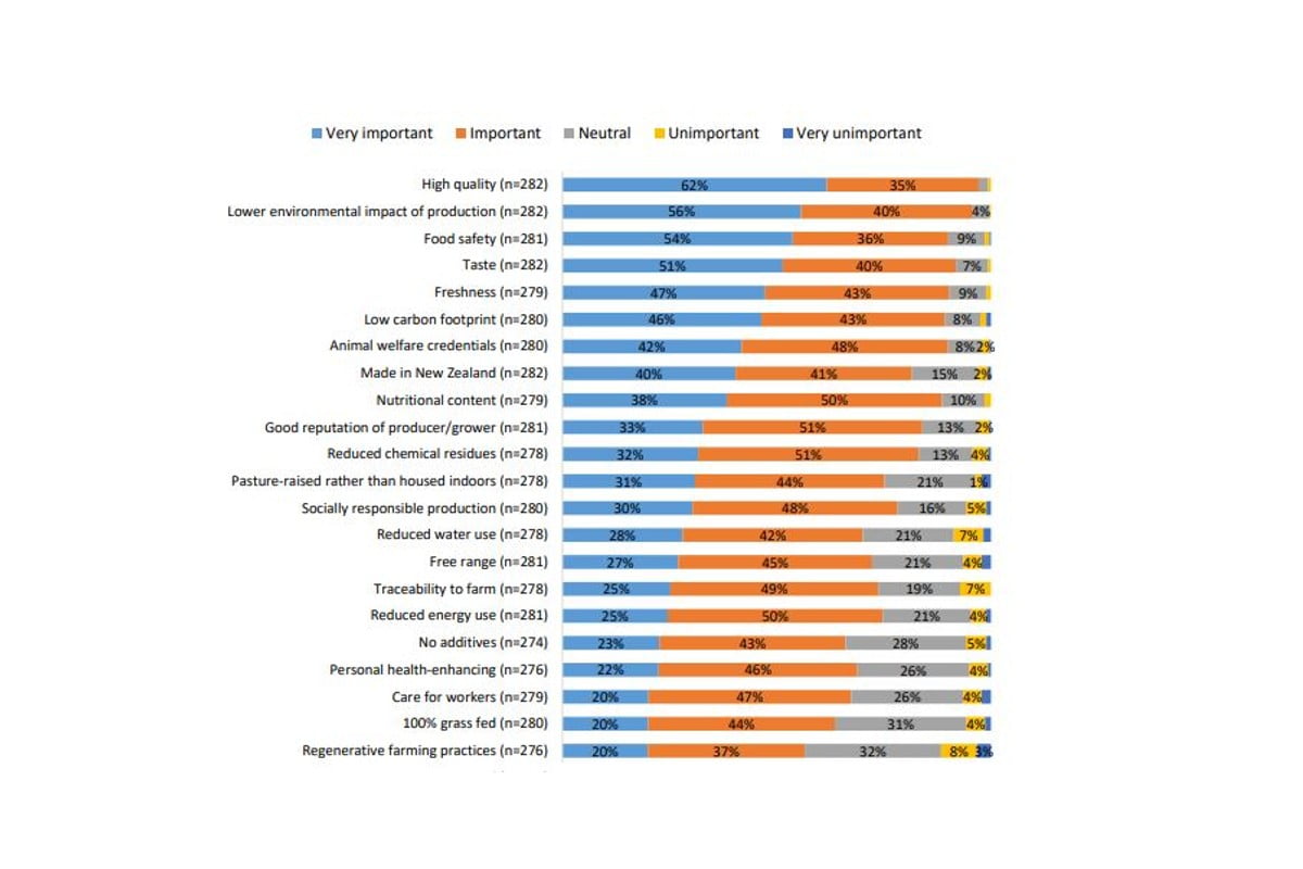
Growing Kai Under Increasing Dry: Adapting to Increasing Drought
Advice to central and regional government, industry bodies, and the research, science and innovation community on what is needed to better support primary sector adaptation…
Guidance
Designing Effective Farm Environment Plans
We have prepared a guidance document for people who need to design effective FEPs, FEP templates and processes. It proses a four-step approach and makes…
Technical Report
Whakapapakainga: A template of cross-generational development for marae-communities
Through case study research in Northland, New Zealand, this thesis investigates the future of papakainga (kin-community settlements) and their marae (ancestral centres of tribal identity).…
Where are we conducting our research?
This interactive map shows the location of all our research projects to help connect you with the research happening in your catchment.
Hover over regions and click to see key information about the projects.
Our Key Collaborators